|
Nickel Laterite Exploration using MALÅ GPR ProEx and RTA antennas
|

TerraLOG Exploration services provides Geophysical services and contracting focused on exploration of coal, iron, nickel gold and other minerals. TerraLOG is a full exploration service provider and provides all steps from field work to interpretations, including data processing and modeling work. The company is primarily engaged in Indonesia and is a branch subsidiary to PT.RecsaLog Geoprima. Services include:
Technologies used:
|
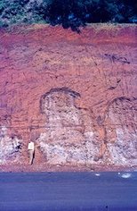
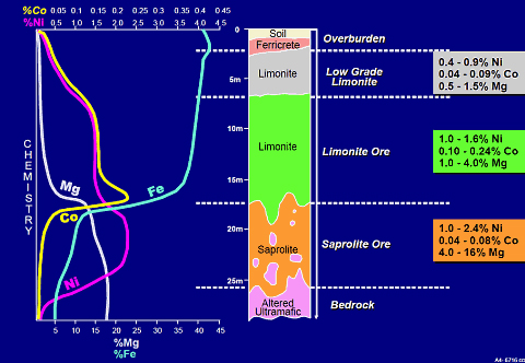
Vertical mineral distribution of Nickel containing Laterite deposit
The complexity of tropical weathering profiles requires more accurate resource delineation and mine planning methods. MALÅ Ground Penetrating Radar solutions, equipped with the unique Rough Terrain Antenna (MALÅ RTA), has shown a tremendous potential for addressing project geology, resource delineation and mine planning issues required to accurately explore and evaluate laterite nickel deposits. The MALÅ ProEx and RTA solution has successfully been deployed at more than 50 laterite sites across 6 continents. In addition, the in-line and flexible design of the MALÅ RTA makes GPR surveys simple even in densely vegetated tropical forests.
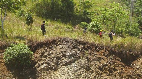
TerraLOG crew performing Ni-Laterite
exploration work in Indonesia using MALÅ ProEx and RTA solutions. TerraLOG Exploration Services is a geophysical consulting group active in Indonesia and led by Agus Hendro Laksono. TerraLOG has actively been using the MALÅ ProEx and RTA solutions for laterite investigations since 2008. TerraLOG and Agus conclude, “MALÅ ProEx and the low frequency Rough Terrain Antennas has significantly increased the value of our deliverables, such as project geology, resource estimations and mine planning of laterite deposits. The MALÅ system has provided invaluable assistance to mine planning by imaging the bedrock weathering texture and the precise location of subsurface pinnacle structures and fault planes. The MALÅ ProEx GPR data, in combination with strategically placed boreholes based on the collected GPR data, has enabled several laterite projects to be upgraded to mineral ore status and thereby categorized as mineral resource.”
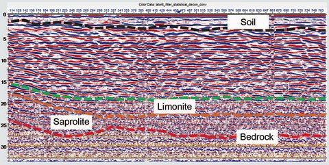
By using GPR to accurately map the volume
of the deposit, coupled with sparsely placed drill holes to confirm layers and grade, TerraLOG creates a geoscientifically sound resource estimate quickly and cost effectively. |