MALA GROUND PENETRATING RADAR - GPR
  • PRODUCTS
    • MALA Products (GPR) >
      • MALA Easy Locator HDR
      • MALA Easy Locator PRO HDR
      • MALA Easy Locator PRO WideRange Dual Frequency
      • MALA Easy Locator Core
      • MALA GroundExplorer GX
      • MALA GPR GeoDrone
      • MALA CX12 Concrete Scanner
      • MALA 3D MIRA HDR
      • MALA 3D MIRA
      • GPR Processing Software
      • MALA Professional Explorer
      • MALA Rough Terrain Carts
    • ABEM Products >
      • ABEM Terrameter LS2
      • ABEM Walktem 2
      • ABEM Terraloc Pro
    • RadioDetection Products >
      • Radiodetection RD7200 / RD8200
      • C.A.T4 and GENNY
      • Radiodetection RD312
      • Radiodetection RD316
      • Radiodetection RD500
    • Trace Rods >
      • Vetter Tracing Rods
      • MSS Tracing Rods
  • Applications
    • Bedrock Mapping
    • Rail Corridor
    • Utility Detection
    • Concrete Scanning
    • Transportation & Infrastructure
    • Environmental & Geotechnical
    • Military & Police
    • Exploration & Mining
    • Education & Research
    • Archaeology
  • Consulting
    • GPR Data Processing
    • Underwater GPR
    • Cemetery Mapping
    • Environment
    • Infrastructure & Engineering
  • Training
  • Rental
    • RTK GPS Hire
    • Dualem Conductivity Meter Rental
  • 2nd Hand Instruments
  • Servicing
  • About Us
  • Contact

Easylocator

BED ROCK MAPPING


Picture
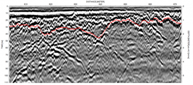
Bedrock is the hard, solid rock most often found beneath the unconsolidated surface materials, such as sand or till, but also as outcrops above the ground surface. The depth to the rock head can vary from zero to several hundred meters and the topography, as well as the quality, of the bedrock can differ significantly.
An understanding of the bedrock is important for many aspects of human activities on Earth. Knowledge of the depth to the bedrock and its properties are essential for:
  • Infrastructure projects, allowing safe and stable construction of buildings, bridges, roads, railroads, airports etc. Aside from the safety aspect, failing to determine the depth to, or quality of, bedrock can also cause both severe cost increases and large delays.
  • Building tunnels or different types of repositories (storage, wells etc.) within the bedrock.
  • Extraction of different types of mineral resources (iron, copper, gold etc.) as well as aggregate and fossil fuel (coal, oil and natural gas).
  • Characterization of groundwater aquifers in bedrock formations, such as porous sandstone or fractured crystalline rock.
  • Mapping areas that can be used for storm water management, due to climate changes and increasing precipitation.
  • Mapping pathways for analysis of groundwater and contaminant flow.

​Today, most bedrock investigation is done by digging or drilling but with the increased use of 3D design tools (on infrastructure and resource mapping projects, for example) the demand for more data coverage is increasing. Attempting to resolve this need with traditional intrusive methods will be extremely expensive and sometimes, with an increasingly ‘crowded’ subsurface, digging and drilling can be most undesirable and risky. Instead, different geophysical tools can be used to assist in the creation of a more comprehensive picture of the bedrock conditions.
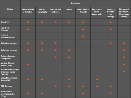
Picture

WHich Technique?

What method and technique to use? Whilst there are many factors involved in deciding upon the correct solution for a given project, these are some of the key considerations:
  • GPR is suitable in non-conductive conditions (e.g. without clayey soils) down to approximately 35 meters
  • TEM is unsuitable in urban areas due to sources of electromagnetic disturbance
  • TEM is suitable for deep investigations (>500 m) where resistivity and seismic methods might be limited by access, equipment power or general survey practicalities
  • Resistivity requires galvanic contact via electrodes of some description which can be both hard and time consuming in environments with bare rock or asphalt etc.
  • If an active (as opposed to passive) seismic method is to be employed the source needs some consideration; it needs to be big enough to get the energy to and from the desired depth and there may be legislative or environmental constraints upon how this is achieved
  • TEM or VES may be sufficient for broad prospection but GPR, ERT and seismic methods are best for more detailed results
  • Seismic methods can provide quantitative appraisal of geological strength and stability
  • TEM is not well suited to differentiating between highly resistive geological units; the method responds better to conductive stratigraphic elements
  • 1D methods (VES, TEM, VSP) are not well suited to identifying confined features like fracture zones and intrusions compared to 2D methods which offer lateral detail 
Combining methods - 
It is often beneficial to combine different geophysical methods to get the best resulting picture of the bedrock conditions due to the overburden conditions, the physical distribution of the bedrock or level of information required. For instance:
  • if the project covers a wide geographical area, GPR can be used more efficiently in highland areas with till and sands, whilst resistivity investigations may be more successful in lowland areas with high proportions of clay and silt
  • it may be beneficial to supplement ERT or seismic methods with TEM soundings through those areas where the bedrock was too deep to be detected by the primary methodology
  • GPR can give excellent detail on the stratigraphy, where the interfaces between geological units lie, but a method which gives a more quantitative result (such as resistivity or seismic refraction) can aid with the interpretation of what material makes up each of those units
Picture
REQUEST MORE INFO
Submit >

Picture
Picture
Home - Products - Applications
​Consulting - Training
​GPR Rental

FOLLOW US

TELEPHONE

0401 058 562
0420 968 765
Privacy Policy
Copyright © 2009-2021 MALA GPR Australia  (ABN 78 132 266 678). All rights reserved.