3D Radar GPR System from MALA (MIRA 3D GPR)3D Radar MALÅ GPR Imaging Radar Array (MIRA) is the most technically advanced GPR system on the market. MALÅ GPR MIRA is a one-pass 3D Radar system providing a cost-effective solution for large scale ground penetrating radar mapping and subsurface object identification.
It is the only system of its kind that seamlessly integrates acquisition, processing, QA/QC, positioning data, interpretation and export of ground penetrating radar data. The MALÅ GPR MIRA system is designed using multiple antennas configured in an Array (see definition under technical specification). Up to 30 antennas can be used simultaneously to gather data in real time. It was designed to retain survey speed regardless of number of antennas used. The MALÅ GPR MIRA System is based on the MALÅ GPR ProEx Control Unit and its MALÅ GPR Array Option. The power within this product lies in its ability to quickly and easily gather full 3D data in broad paths, so called “swots”. Results are processed in 3D, displayed and interpreted through a dedicated software package and then exported into suitable GIS or CAD data formats. 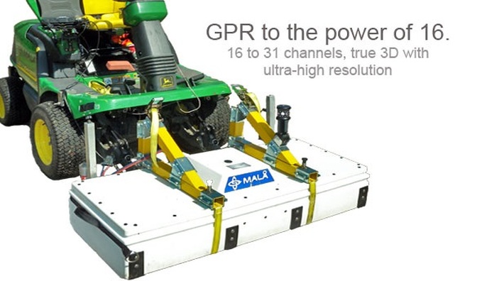
Application includes:
In Australia the MIRA system would typically be used for high-level service locating, road mapping and archaeological applications. The underground utility infrastructure system in Australia is relatively poorly documented and the MIRA system enables organisations to quickly generate a 3D map of the utilities. Not only are the utilities located efficiently and with maximum detection rate, accurate their location and depth is also recorded for future reference. The system is suited for industry leading private organisations operating on the highest level and who are industry leading within their field. Some training is required and dedicated personnel for its operation is recommended. Fast, easy and true 3D data acquisition
As opposed to normal multi-channel systems, the MIRA system enables fast and easy, true, 3-D data acquisition. From a user perspective this means that large areas can be mapped without loss of information and that the method is suitable for almost any kind of, shallow, subsurface investigation, i.e. targets with arbitrary shape, layers and linear objects are mapped equally well. The MIRA system consists of several separate transmitter and receiver antennas combined into one single antenna array unit. In operation, the antenna array is tracked and positioned by a robotic (self-tracking) total station or a RTK GPS for precise positioning. This give several parallel profiles exactly positioned at the same time, resulting in a seamless 3D picture of the subsurface, with a high-resolution of subsurface features both in horizontal and vertical direction.
The system and its array technique uses a number of transmitter and receivers simultaneously to measure several parallel profiles in one sweep and by doing so, the survey becomes detailed, accurate and extremely cost-effective. 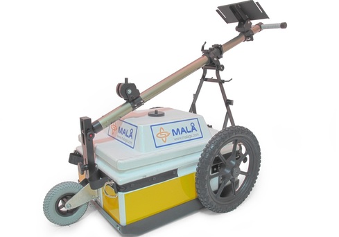
|
REQUEST MORE INFO
RENT A MIRA 3D GPR SYSTEM
This unit is available for rental Australia wide. Download Spec sheet:

| ||||||
|
|